To Create Points Along a Polyline or Surface Contour Using Distance and Surface Elevations
Create points using elevations from the surface. The points are created along a polyline based on a specified distance.
The Prompt For Elevations setting, specified in the Points Creation settings, does not affect how you are prompted during this command.
- Select settings and create styles, layers, point groups, and description keys.
-

 .
. - Select a surface.
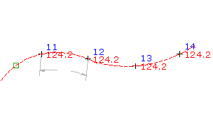
- Enter the distance between the points.
- Select the polyline or surface contour along which to place the points.The points are placed along the polyline or surface contour at the specified interval.
- If prompted, for each point, enter the point name and description.
Note: Many factors affect how the point is displayed.
posted by Digital Marketing @ November 28, 2019
0 Comments
![]()

0 Comments:
Post a Comment
Subscribe to Post Comments [Atom]
<< Home