Position Markers - Autocad
Position markers are annotations you place in model space to mark and label a geographic location.
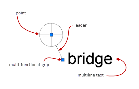
A position marker consists of a point, a leader line, and multiline text. You can use the multi-functional grips to lengthen the leader line or change the position of the multiline text.
You can control the size of a position marker with the GEOMARKPOSITIONSIZE system variable. However, this system variables controls the size of the position marker only at creation time. To resize position markers after they are placed in the drawing area use the properties palette.
In order to easily find position markers when zoomed out, position markers contain zoom invariant yellow indicators. However, if you use the 2D Wireframe visual style, the yellow indicator does not display. In such a case, you can use the QSELECT and FIND commands to find position markers. We recommend that you use keywords in the multiline text to make it easier to search for position markers with the FIND command. You can also use the notes property to record notes about the geographic location marked by the position marker. Unlike the multiline text object, the notes are not displayed in the drawing area. However you can inspect and edit notes with the properties palette. The FIND command checks the notes property in addition to checking the multiline text object. This gives you the ability to find position markers by searching for keywords within the notes property.

When you move the cursor over a position marker, a tooltip displays its geographic location as latitude and longitude values. These values honor the settings of the GEOLATLONGFORMAT and AUPREC system variables. If you remove geographic location information from the drawing file, the tooltip also goes away.
The program prevents you from exploding position markers as long as the drawing file contains geographic location information.
posted by Feature and Technology @ May 03, 2019
0 Comments
![]()

0 Comments:
Post a Comment
Subscribe to Post Comments [Atom]
<< Home